|
|||
Prototype inspirations for Inglenook Sidings layouts |
|||
U.S.A. This portrait of Selby is based
on information and material kindly provided by Dan
Mitzel. |
|||
| Selby, South Dakota, is located at milepost 784 from Chicago Union Station, along the old Aberdeen Division, 3rd Subdivision (running from Aberdeen west to Mobridge) of the Chicago, Milwaukee, St. Paul & Pacific (CMStP&P) - better known as the "Milwaukee RR". | |||
|
|||
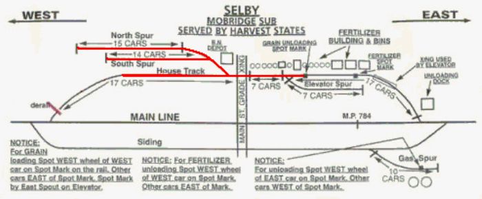
| Today, this is the Mobridge Sub of BNSF's Twin Cities Division, and the tracks at Selby incorporate an Inglenook arrangement (marked out in red), illustrated by a Burlington Northern SPINS map of Selby (more on SPINS and other railroad schematic maps further below on this page). | |||
|
|||
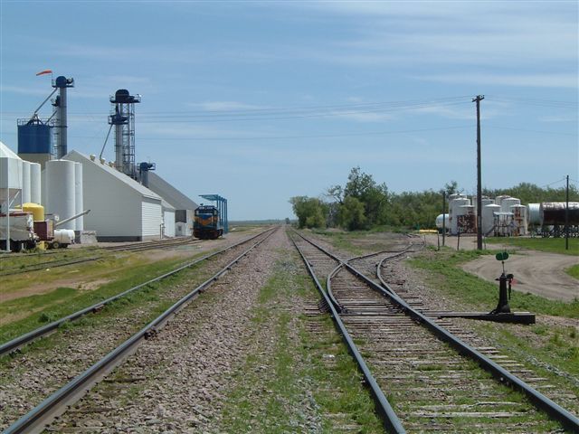
| The tracks of the Inglenook
section (west-end House Track, South Spur and North Spur)
are elevator tracks used during the harvest season.
Off-season, they are used for the storage of MoW
equipment as well.
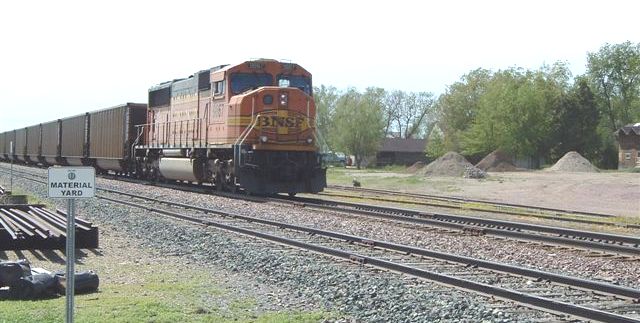
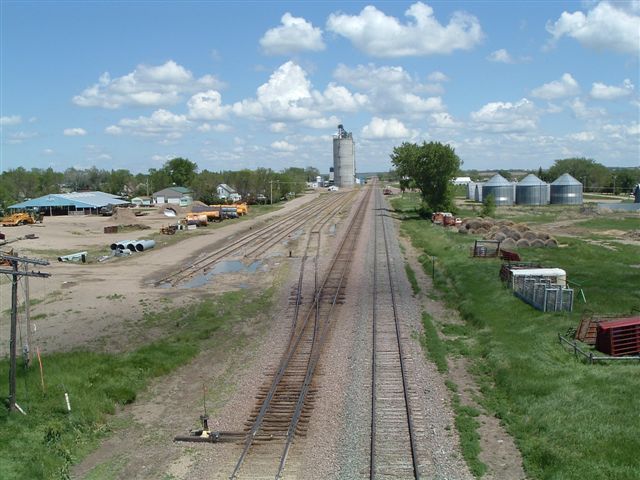
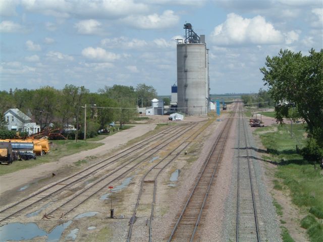
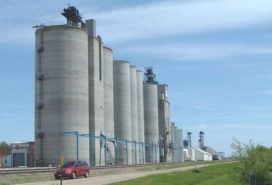
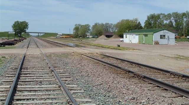
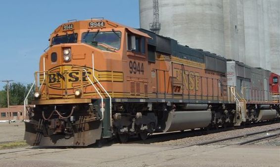
Looking east, the Inglenook track arrangement can be seen to the left of pictures 1 and 2 (viewed from the Highway 12 overbridge). Picture 3 (again looking east) illustrates just what the track could be made to look like on a layout, and picture 4 shows the size of the grain elevators, which would make an impressive backdrop feature. |
|||
Looking west, the Inglenook track arrangement can be seen to the right of this picture, with the Highway 12 overbridge in the background. |
|||
|
|||
| On a layout, the track
lengths would be selectively compressed, making the
west-end House Track the 5-car-capacity siding whilst the
South Spur and North Spur would hold 3 cars each. The
east-end House Track could be used as the switching lead
(headshunt), and the Elevator Spur could be included as
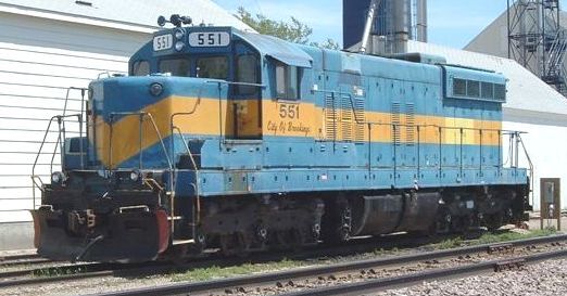
the track where the local switcher is kept. To operate the layout, one could use a Milwaukee Road, BN (post-1982), or BNSF (post-1995) Geep, or the former-DM&E SD-7 elevator switcher as seen at Selby today. Common rolling stock is 50-foot covered hoppers appropriate to the era, with MILW, BN or BNSF equipment dominating. Occasionally, there have also been bulkhead and center-beam lumber cars parked on the north and south spurs for unloading. Another option for introducing heightened operations would be for a through train to emerge from hidden staging to drop off the inbound cut of five cars for the elevator switcher to work. The same mainline engines could pick up the outbound grain "loads" to complete the session. |
|||
SPINS, CLIC and ZTS SPINS (also known as CLIC or ZTS on other RRs) are industry schematic maps provided by the operating companies to their road crews. They list industry information such as where to spot loaded or empty cars for unloading/loading, track capacities and other pertinent information. Whereas in the old days crews would know where to spot cars by talking to the industry manager - it was a slower pace of life then - the maps provide the same information in a consistent format. These days in the U.S. crews are qualified on multiple lines or subdivisions and tend to move around a lot. Before a young "rail" could learn what to do and where from the more veteran crew members who held enough seniority to hold a particular union job for a long time. The maps help here with a younger workforce - there has been thousands of veteran rails retiring lately. The acronym SPINS is an abbreviation for Southern Pacific Industry Numbering System - it originated on the SP. Why BN adopted the same term is unclear, but somehow it stuck. CLIC (Car Location Identity Codes) was a Santa Fe term for the same thing, as was ZTS (Zone, Track, Spot) on Conrail. They're very helpful for the prototype modeler as they show the general arrangement of the track at a particular industry or station. Since modellers usually selectively compress and twist the track around to fit the available space anyway, they really are just what most modelers are looking for - prototype layout plans. |
|||
Back to the Model Railways Shunting Puzzles Website main page |
|||
 |